We went to Dayville, Oregon, where the fossils are friendly, the Dayville Cafe has the 35 flavors of the best homemade daily pies, and John with the men in Dayville. We are parked at the Fish House Inn and RV park. We got the last site next to the barn and the bar.
Down the road is Picture canyon as we entered the John Day Fossil beds and Sheep Rock under blue skies.
Sheep Rock from the Thomas Condon Paleontology and visitors center for the John Day Fossil Beds National Monument. The colorful landscapes of the monument showcase 40 million years of Oregon's ancient history. Evidence of over 2000 fossilized plants and animals we have never heard of before, ecological changes and violent volcanic activity. It has three different sites. Today we are at the Sheep Rock unit.
After the visitors center we hiked the Blue Basin overlook and the Island of time trails. Overlooking the basin, which looked more green to me. The Island of time was a trail right up into the colorful canyon. Thousands of fossils have been found in the formation of volcanic tuft.
The sun back lit the grasses on our way out. There are 13 bridges over the now dry watercourse in the canyon. You can see 4 of them here.
We drove on the Journey through time Oregon scenic byway. A couple of skulls seen in the visitors center and a thistle blossom. Seed head, asters and other flowers seen along the trail.
There must be some smoke in the air because this looks like a smoke sunset. We drove to Mitchell, Oregon today. It is the gateway to the Painted Hills-another section of the John Day Fossil Beds National Monument. Sign at the Painted Hills, Don’t hurt the dirt-basically saying don’t walk on the dirt where there may be fossils, only on areas with plants, or better yet, stay on the trail. Seed head of a bush.
We are parked in the town of Mitchell’s RV park in the city park. It has 4 spaces, really close together. So far no one else has come in so we have plenty of room. It is the only place to park an RV close to the Painted Hills, the next is about 25 miles away. The first view of the Painted hills.
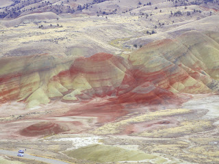
The over look trail leads you to these spectacular views of color-splashed hills, part of the lower John Day Formation. It was overcast so the colors didn’t photograph well. The yellow layers are the drier millennia and the red ones are the wet tropical ones. The layers help them study the changes during climate change. The black areas are associated with plants that fixed magnesium in the soil. The Carroll Rim trail leads to an outstanding over view of the landscape.
We ate lunch up there waiting for the sun to come out over them, but no such luck. The Painted Cove trail winds through yellow, crimson and lavender hills, giving you a close view of the popcorn-textured claystones that distinguish the Painted hills.
This is the only area with some white in it. It is ash from a cataclysmic eruption with clouds of super heated volcanic ash and gases. The sun had finally come out. The Red Scar Knoll/Red Hill trail lead ends at this strikingly bisected hill of tan and red claystone.
.
The painted hills overlook with the sun out, not sure it looks any better in the photos. Beautiful, historic downtown Mitchell. Population 130. Step back in time kind of town.
It did have a brewery, the Tiger City Brewery. Here is John with his IPA. There were signs all over the fossil beds saying removal of rocks or fossils strictly prohibited. One of the trails took us to Leaf Hill where they collected 1000's of leaf fossils, so the sign says stay off the hill and no fossil collection. This strange little free museum in town had this dusty pine needle basket. A spike buck, one of the herd in town . Chicory flower and part of the town herd of turkey’s.
John found this circle of stones, though maybe it was a ceremonial native American ring, but the ranger told him it is a peace sign someone added too. Sunflower, red clay dirt in the formations and a weird rock, looked like some kind of a monolith. Another oddity in town was this very modern Tesla charging station by this abandoned Whole in the Wall handcrafted curiosities unlimited. The building has only a half door and the ceiling is caved in.
Who was John Day? He never came to this region. He was in Oregon in 1812 on
an expedition to Astoria down the Columbia river. At the mouth of what is now
the John Day river he was robbed of all his belongings, including his clothes.
He was rescued by another party going to Astoria. Whenever others would pass the
spot of the incident they would point out where he had been robbed, so the river
was named after him. The towns, the monument and many other things are named
after the river.


No comments:
Post a Comment
Note: Only a member of this blog may post a comment.